Matrix seismic lines (2006-2008)
Description
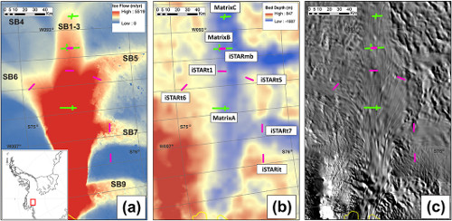
These seismic reflection profile tracks identify where field surveying was conducted during the 2006/2007 and 2007/2008 field season on Pine Island Glacier.
These ‘Matrix’ lines were located on the main trunk of PIG and further up the main tributary. Long lines were acquired across ice flow and intersecting shorter lines acquired along flow. One additional seismic line was acquired in 2014/15, iSTARmb, and is a repeat survey of a 5 km section of the MatrixB line.
Seismic reflection profiles were collected with 100Hz geophones.
References
1. Brisbourne, AM, Smith, AM, Vaughan, DG, King, EC, Davies, D, Bingham, RG, Smith, EC, Nias, I & Rosier, SHR 2017, 'Bed conditions of Pine Island Glacier, West Antarctica' Journal of Geophysical Research: Earth Surface. DOI: 10.1002/2016JF004033. Available Here
Figures

Figure 1: Location of seismic profiles across Pine Island Glacier used in this study. The inset in Figure 1a shows the location of the detailed maps of PIG within West Antarctica (red box). (a) Ice-flow speed in m yr−1 from interferometric synthetic aperture radar (InSAR) measurements [Rignot et al., 2011b]. The “SBx” annotation refers to the tributary nomenclature of Stenoien and Bentley [2000]. (b) Bedmap2 bed elevation [Fretwell et al., 2013]. iSTAR seismic lines (acquired 2014/2015) are in magenta, and Matrix lines (acquired 2006–2008) are in green. (c) Moderate Resolution Imaging Spectroradiometer (MODIS) image [Scambos et al., 2007]. Brisbourne et al., 2017