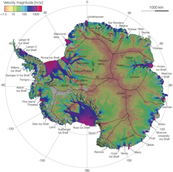
Bathymetry and MEaSUREs Ice Velocity
Hillshade and Bathymetry
Layer group comprising DEM hillshade dataset with a suitably styled surface DEM.
MEaSUREs InSAR-Based Antarctica Ice Velocity
This data set, part of the NASA Making Earth System Data Records for Use in Research Environments (MEaSUREs) Program, provides the first comprehensive, high-resolution, digital mosaics of ice motion in Antarctica assembled from multiple satellite interferometric synthetic-aperture radar systems. The majority of the data were acquired during the International Polar Year 2007 to 2009.
References
1. Rignot, E., J. Mouginot, and B. Scheuchl. 2011. MEaSUREs InSAR-Based Antarctica Ice Velocity Map [indicate subset used]. Boulder, Colorado USA: NASA DAAC at the National Snow and Ice Data Center. doi:10.5067/MEASURES/CRYOSPHERE/nsidc-0484.001. Available here
2. NSIDC InSAR-Based Antarctica Velocity overview
Figures

Figure 1: Antarctic ice velocity derived from ALOS PALSAR, Envisat ASAR, RADARSAT- 2 and ERS-1/2 satellite radar interferometry color coded on a logarithmic scale. (Rignot, Mouginot and Scheuchl, 2011)