iSTAR GPS sites (2013/2014)
Description
Eleven GPS stations were installed in 2013/14. Each station was comprised of 2 wind generators, a solar panel, 4 sealed lead acid batteries, a GPS receiver and an antenna. This modular setup provides long-term power supplies in a robust, reliable way.
The GPS systems installed allowed comprehensive monitoring of ice flow on Pine Island Glacier and tributary glaciers, as well as identifying the upstream transmission of ice velocity changes. In addition they help measure ice velocity trends and horizontal surface strain rates
They were removed during the winter 2014/15 traverse and data used in research to model and help identify Pine Island Glaciers recent responses.
References
2. iSTAR - report from the field
Field photo

Deploying a GPS station at one of the iSTAR sites to record the movement of Pine Island Glacier. Alex Taylor, BAS
Figures
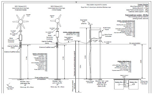
Figure 1: iSTAR-C remote GPS power system design deployed on Pine Island Glacier. iSTAR - Making it happen