Strain rate measurements (stakes)
Description
Strain rate measurements were conducted at each GPS site to identify the movement speed and dynamics of Pine Island Glacier during the science traverses.
All sites had 5 stakes, 1 in the centre and the others 1km away on the corners of a square. Data collection was successful and complete; all 5 stakes were measured during both seasons, except for sites 09 and 13.
For 09 and 13 only 4 stakes were measured, which was still enough to obtain the strain rates.
The following quantities were measured for each site:
• psx and psy: polar stereographic coordinates of the reference stake at its initial location, obtained from PPP processing
• height above WGS1984 geoid of the reference point
• vx and vy in m/yr: horizontal velocity components of the reference stake, obtained from the difference between its final and initial location
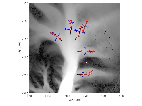
• E1 and E2 in 1/yr: first and second principle strain rate components, obtained as an optimal solution (least square fit) to all displacement data. Positive values are compressive, negative values extensive.
• Theta in rad: angle of the 1st principle strain rate direction wrt polar stereographic grid
• Psx_2 and psy_2: polar stereographic coordinates of the reference stake at its final position location.
References
1. iSTAR - report from the field
1. iSTAR - Initial Environmental Evaluation
Field photo

Strain rate glacial pole in situ at a field site Jan De Rydt, BAS
Figures

Figure 1: A map of strain rates overlaying flow speed identified from strain rate measurements on Pine Island Glacier. Alex Taylor, BAS