Satellite Altimeter elevation change - WAIS
Description
Measurements from five satellite altimeter missions were used to obtain an uninterrupted record of ice sheet elevation change over the Amundsen Sea Embayment, West Antarctica, since 1992.
These data identify the onset of surface lowering arising through ice-dynamical imbalance, and the pace at which it has propagated inland, by tracking elevation changes along glacier flow lines.
18 flow lines are presented in the data with each point identifying the year when surface elevation rate exceeds 1m/yr according to a simple linear model. Data pre- 1992 are extrapolated back in time as no altimetry mission data exists.
References
1. Konrad, H., L. Gilbert, S. L. Cornford, A. Payne, A. Hogg, A. Muir, and A. Shepherd (2017), Uneven onset and pace of ice-dynamical imbalance in the Amundsen Sea Embayment, West Antarctica, Geophys. Res. Lett., 44, 910–918. Available here
2. ESA - Satellites track variations in Antarcticas glacial retreat
Figure
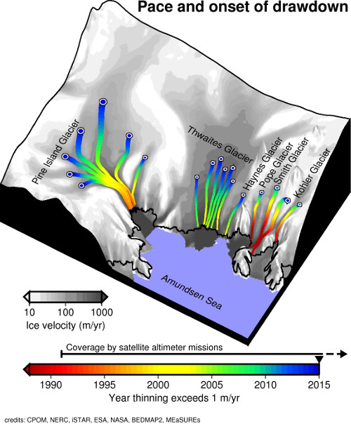
Figure 1: Pace and onset of ice sheet elevation change where thinning exceeds 1 m/yr between 1990 and 2015. Hannes Konrad