2.4. Drop down icon options
![]()
Figure 22: Drop down icon for individual data layer iSTAR GIS
For each data layer additional styling and viewing options are available via the drop down menu. For each layer the user can:
- ‘Zoom to layer extent’: change main map view to location of specific data layer
- ‘Apply alternate style’: for certain layers the user can change the style of the layer to another assigned layer style
- ‘Filter by attribute’: for certain layers the user can filter the layer attribute table to find specific data e.g. filter Antarctic bases with a berth capacity > 300.
- ‘Change layer transparency’: change the transparency of the layer from 0% to 100 %
- ‘View time series’: for certain layers the user can viewer a time-series of the dataset information e.g. daily sea ice concentration or daily ship track position
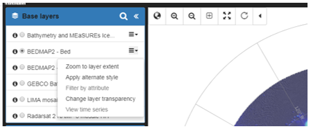
Figure 23: Drop down menu options for an individual data layer. iSTAR GIS