1.2. Measure button

Figure 4: Measure distances button on the webmap header panel ADD
The measure tool allows you to measure a distance (with specific units) of a straight line, the area of a user-defined area and elevation. For a straight line the user can select kilometres, metres, miles and nautical miles and measure line length along multiple vertices.
To measure an area the user can select area units (square kilometres, square metres, square miles, and square nautical miles) and ‘draw’ the area perimeter by clicking to create shape vertices and ‘double clicking’ to finalise the drawn area.
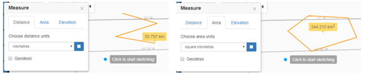
Figure 5: (Left) Measuring a distance of a straight line. (Right) Measuring an area of a polygon with multiple vertices. ADD